近半个多世纪以来,在全球气候变化的作用下,青藏高原整体上呈变暖趋势(0.39 ℃/10a)。气候变暖将导致山区冰川退缩和积雪消融,但是,中纬度山区的最大降雪率是发生在当温度接近冻结温度时,此时空气中可以凝结更多的水汽。针对变化环境下的青藏高原降雪率变化,中国科学院新疆生态与地理研究所陈亚宁研究团队基于71个地面观测站点的日尺度观测资料,运用温度阈值模型,模拟了1960至2014年期间青藏高原降雪率的时、空、季节及海拔等变化。
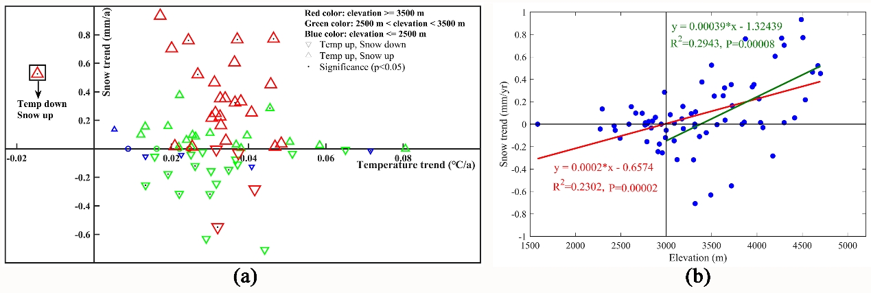
研究结果表明,青藏高原的东部和东北部区域随温度的上升,降雪率呈减少趋势,而中部和西部区域却呈现增加趋势;同时,1961至1990年和1971至2000年期间高原降雪率以减少趋势为主,而1981至2010年期间和1991至2014年期间降雪率以增加趋势为主;此外,冬季的降雪率呈增加趋势,而夏季呈减少趋势。中低海拔区域的降雪率呈减少趋势,高海拔区域(3500米以上)呈增加趋势,并得到降雪率变化的转化海拔高度大约为3396米。最大降雪率发生在1℃至2℃之间,当平均气温高于这个温度时,降雪率呈减少趋势,反之呈增加趋势,这对于理解变暖条件下降雪率变化具有重要意义。该研究详细探讨了青藏高原变暖环境下降雪率的变化。研究成果changes of snowfall under warming in the tibetan plateau发表在journal of geophysical research-atmospheres上。

figure. (a) temperature and snowfall trend magnitudes (1960–2014) classified according to station elevation band. red symbols mean that elevation is greater than 3500 m, green symbols between 2500 and 3500 m, and blue below 2500 m. upward pointing triangles mean warming (temperatures) or more snow, and downward pointing triangles the opposite. black dots represent significant trends (p = 0.05). (b) relationship between snowfall trend magnitude (mm/yr) and elevation (m). critical elevations where snow trends change sign are represented by where lines cross the central x axis.
 附件下载:
附件下载: